
Just west of Kentucky Route 255, a road south of Park City, a brown line makes a lap around a patch of ground and arrives back where it started. There’s a smaller oval inside it, about the shape of a potato. A few miles away on the same sheet, another line comes around to meet itself. Imagine walking from the heavy brown line to the next line inside it at each spot. One walk costs you ten feet of climbing. On the other you lose ten feet.
The two scraps below come from a U.S. Geological Survey map of south-central Kentucky, near Mammoth Cave. Both are right side up. In A, look for the heavy line numbered 750. In B, find the one numbered 550. You could stand higher above sea level at A and still be standing in a hollow. What matters for this puzzle is how your height changes over those last few steps.
Which loop takes you downhill?
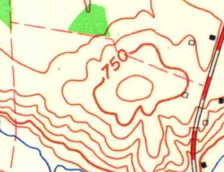
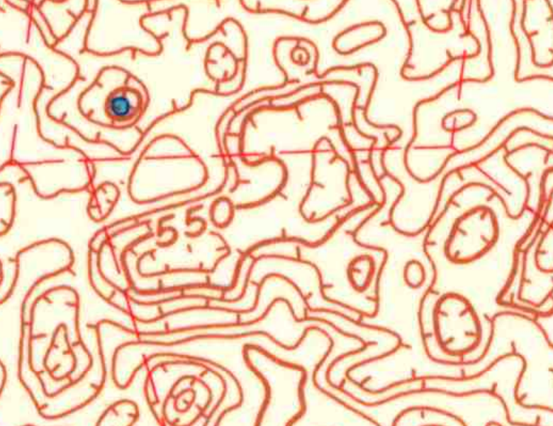
Two details at the same enlargement, north up. U.S. Geological Survey, Park City, Kentucky, 1966. Public domain. Full sheet and margin (PDF)
Check my reading
A takes you uphill. Try following its smooth inner oval.
You found it. Follow the short strokes into B.
B is the hollow. The little strokes, called hachures, point down the slope. At the left end of B, cross the heavy 550-foot contour toward the small loop tucked under the number. That next line is 540 feet. In A, the first oval inside 750 is 760 feet. Each crossing changes the height by ten feet.
A pencil trip across B
The dots mark four contour crossings along our dashed line. The curve between them is a sketch. The sheet gives no surveyed floor height here. Vertical scale exaggerated.
Walk around the line, then across it
Imagine walking the whole 750-foot contour with one hand on an invisible handrail. The rail would twist this way and that around the field, yet your hand would stay at the same elevation all the way around. Now let go and head for the little oval. How much higher would someone have to set a second rail to follow that line?
That number lives under the scale bar at the bottom of the sheet. Park City’s contour interval is ten feet. The heavy numbered contours give you a place to start counting. A thin line is worth just as much of a step as a heavy one. The thickness helps you keep your place. It would be easy to lose count among all the tightly packed lines on the north side of this map.
What the pencil crosses twice
Look at the dashed crossing in the answer. It cuts through the left-hand lobe of the longer loop. From the first dot to the second your pencil drops ten feet. Then it meets the very same inner contour on the way out. Those middle dots sit at the same height, with a patch of lower ground between them. Draw the two dots at their proper heights on a scrap of paper and you have the beginnings of a side view.
How far down should the pencil go between the dots? There’s no figure printed on the floor and no further contour in that little pocket. You can draw a dip there. Giving its deepest point a precise elevation would take another measurement. The same restraint applies on the hill. Its innermost oval marks a height you can recover by counting. It doesn’t give you the last inch of the summit.
Where the rain goes
There’s a reason a map near Mammoth Cave offers so many chances to try this. South of the park lies a plain pocked with sinkholes. The National Park Service describes rainwater draining into the ground, traveling through caves and emerging at springs along the Green River. A hollow can gather water without keeping a pond. On the full sheet some of the little pockets contain patches of blue. In others the paper inside the loop is bare.
It’s tempting to send an imaginary raindrop all the way from our chosen loop to a particular cave. The marks will get it downhill. To follow it underground you’d need evidence of where the water actually goes. For one last turn of the puzzle, look at Wizard Island in Oregon’s Crater Lake. You could climb the island from its shore, walk over the lip of its summit crater, and start downhill again, all without turning around.